
KOTTAYAM

Kottayam is a city in the Indian state of Kerala. It is located in central Kerala and is also the administrative capital of Kottayam district. Bordered by the lofty and mighty Western Ghats on the east and the Vembanad Lake and paddy fields of Kuttanad on the west, Kottayam is a land of unique characteristics. Panoramic backwater stretches, lush paddy fields, highlands, hills and hillocks, extensive rubber plantations, places associated with many legends and a totally literate people have given Kottayam District the enviable title: The land of letters, legends, latex and lakes. The city is an important trading center of spices and commercial crops, especially rubber. Most of India's natural rubber originates from the acres of well-kept plantations of Kottayam, also home to the Rubber Board. Kottayam is also called as "Akshara Nagari" which means the "city of letters" considering its contribution to print media and literature. Kottayam Town is the first town in India to have achieved 100% literacy (a remarkable feat achieved as early as in 1989). English education in South India did actually start at the Old Seminary here at Kottayam in 1813. The first printing press in Kerala was established (CMS Press) here in 1821 by Rev.Benjamin Baily. The first college in the State (CMS College) was also started here at Kottayam in 1840. Maiden printed Malayalam-English and English-Malayalam Dictionaries were published from Kottayam in 1846 and 1847 respectively. The first and only Cooperative Society of writers, authors and publishers (SPCS), for publishing books and periodicals was set up here in 1945. Kottayam is the hometown of a vast number of books and periodicals and is the center of publishing business in the State. Kottayam is the first town in India selected by the Ministry of Environment and Forests, Government of India to be transformed as an Eco City. The Sri K R Narayanan, the former President of India hails from Kottayam District. Kottayam is the ideal take off point for visits to Peermade, Munnar, Thekkady, Ernakulam and the temple city, Madurai. It is also a gateway to the pilgrim centers of Sabarimala, Mannanam, Vaikom, Ettumanoor, Bharananganam, Erumeli, Manarcaud, and so o
KOLLAM
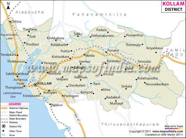
Kollam is located in the the South west coast of kerala. It is an old sea port of the Arabian sea coast. Kollam occupies an area of 2,491 sq. km. According to the census of 2001, the total population of the district is 25,84,118 with the population density of 1037 people per square kilometer.
Agriculture is the primary source of income in Kollam other than various industries of the region. Paddy, coconut, tapioca, rubber, pepper, mango, banana and cashew are grown here.
- Achencoil
- Chavara
- Oachira
- Thangassery
- Thenmala
PATHANAMTHITTA

Pathanamthitta is a town and a municipality situated in the central Travancore region in the state of Kerala, south India, spread over an area of 23.50 km. It is the administrative capital of Pathanamthitta district. The city has a population of 38,000. The Hindu pilgrim centre ofSabarimala is situated in the Pathanamthitta district; as the main transport hub to Sabarimala, the town is known as the 'Pilgrim Capital of Kerala'. Pathanamthitta is a fast-developing city and business center.
Transportation
[edit]Air
Thiruvananthapuram International Airport (113 km) and Cochin International Airport, at Nedumbassery, Kochi (142 km) are the nearest airports. The proposed Aranmula international Airportis just 14 km from Pathanamthitta.
[edit]Rail
Tiruvalla (Code: TRVL) (30 km) is the only Railway Station in the District. Chengannur (26 km) is the nearest Railway station. Direct Bus services to Pathanamthitta are operated from Tiruvalla and Chengannur. Tiruvalla and Chengannur Private Bus Stands are located near the Railway Stations. The proposed Angamaly - Erumely - Punalur and Tiruvalla - Ranni- Punalur Railway lines pass through Pathanamthitta district.

[edit]Road
Pathanamthitta is the meeting point of two major State Highways T.K.Road (SH - 07) and Main Eastern Highway ( Punalur-Muvattupuzha Road / SH - 08 ). The city is well connected to major towns and cities inside and outside Kerala by the State run K.S.R.T.C and private buses as well as Luxury Services. Both the KSRTC and private buses play equal roles in satisfying the transportation needs of the town. The cities of Thiruvananthapuram, Kochi, Thrissur etc. are connected by KSRTC services whereas hi-range townships like Punalur, Kumali, Pala and the Malabar Area of Northern Kerala are connected by private bus services. Plenty of A/C Luxury Bus services are operated from Pathanamthitta to Bangalore, Chennai, Mangalore and Mumbai on a daily basis.
KSRTC bus stations in pathanamthitta district are, Pathanamthitta,Thiruvalla,Adoor,Pandalam,Mallapally,Ranni,Pamba
[edit]Culture zone
Places around Pathanamthitta city within a distance of 15 km include Ranny, Vadaserikara, Kozhencherry, Kadammanitta, Vazhamuttom, Pandalam, Manjinikara, Omallur,Malayalappuzha, Kodumthara, Muloor Smarakam, Kodumon, Ayroor Cherukolpuzha, Kaipattoor, Mylapra, Thumpamon, Maroor, Pramadom, Konni and Valamchuzhy. The places beyond these are Thiruvalla, Nilackal, Parumala,and Maramon. Pathanamthitta city lies on the road route to the pilgrim town of Sabarimala, which is 65 km away. The famous Chettikulangara temple, at Mavelikkara is about 35 km from Pathanamthitta.The famous Padanilam Parabrahma Temple is situated 26 km from Pathanamthitta.
Maramon Convention is the highest peoples gathering in Asia.
IDUKKI
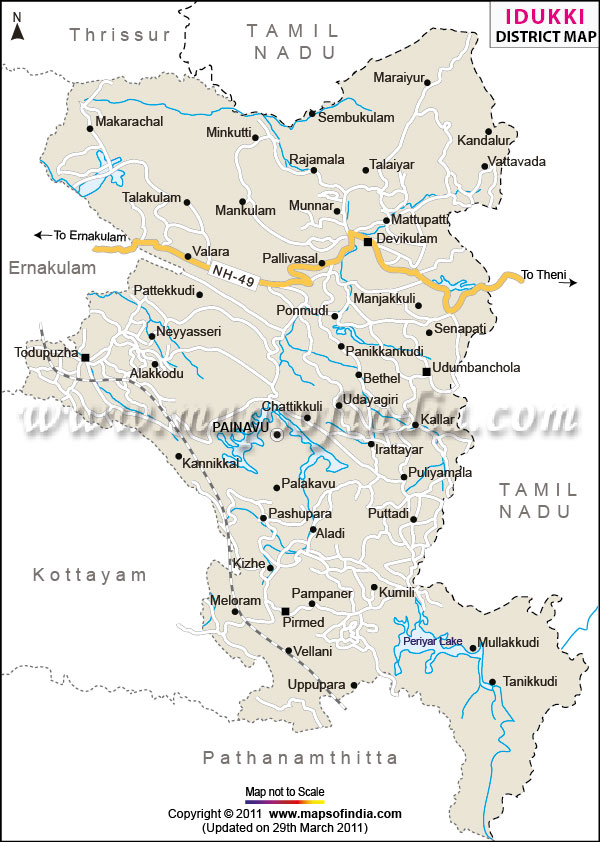
Idukki has an area of 4,479 km2 (1,729 sq mi) and is the second largest District of Kerala (the largest being Palakkad). Rugged mountains and forests cover about 97 percent of the total area of the District. The district borders the Kerala districts of Pathanamthitta to the south,Kottayam to the southwest, Ernakulam to the northwest and Thrissur to the north and Coimbature, Dindigul and Theni Districts inTamilnadu to the east.[1]
Anamudi, the highest peak in India south of Himalayas, is in the Kuttampuzha Panchayat of Adimali Block, in the Kannan Devan Hills Village of Devikulam taluk. Thirteen other peaks in the district exceed a height of 2,000 m (6,600 ft). The Periyar, Thodupuzhayar andThalayar are the important rivers of the district.
The four taluks (subdistricts) in the district are Devikulam, Udumbanchola, Peerumade and Thodupuzha. The taluks contain 65 villages between them.
Thodupuzha is the only municipal town in the district. Munnar is a census town.
The largest village is Kannan Devan Hills of Devikulam taluk with an area of 557 km2, and Kudayathoor of Thodupuzha taluk is the smallest village with an area of 21 km2.
There are eight community development Blocks: Devikulam, Adimali, Nedumkandom, Azhutha, Kattappana, Idukki, Elamdesom and Thodupuzha. There are 51 Panchayaths in the district. Thodupuzha is the only Municipality and Idukki is the only township in the district. Munnar panchayat of Devikulam block is the largest in the district with an area of 557 km2 and Karimkunnam in Thodupuzha block is the smallest panchayat of the district with an area of only 22 km2. The district headquarters were originally located at Kottayam and moved to Painavu in June 1976. Developmental activities are co-ordinated by the District Rural Development Agency.
Protected areas
This district has several protected areas including: Periyar Tiger Reserve in the south, Kurinjimala Sanctuary to the east, Chinnar Wildlife Sanctuary to the northeast, Eravikulam National Park and Anamudi Shola National Park to the north, Pampadum Shola National Park to the south and Thattekad Bird Sanctuary in the west. These protected areas are well known for several threatened and endemic species includingTiger, Nilgiri Tahr, Grizzled Giant Squirrel, Nilgiri Wood-pigeon, Elephant, Gaur, Sambar Deer, Purple Frog and Neelakurinji.[3][4]
Idukki is known for its green mountains, streams and spices.[citation needed] It is one of the a main tourist destinations in Kerala[citation needed]with its hill stations, Devikulam and Munnar, surrounded by lush hills, tea plantations and valleys. Mattupetty, is the headquarters of the Indo-Swiss Cattle Project, about 11 km away from Munnar
ALAPPUZHA
Alappuzha ( pronunciation (help·info)) (Malayalam: ആലപ്പുഴ), also known as Alleppey, is a city in Alappuzha District of Kerala state of southern India.It is the administrative headquarters of Alappuzha District.This town is considered to be the oldest planned town in this region and the lighthouse built on the coast of the town is the first of its kind along the Arabian coast (reference encyclopedia of Kerala in Malayalam language). As per 2001 census Alleppey is the sixth largest city in Kerala with an urban population of 177,029.[1] Alleppey is situated 62 kilometres (39 mi) to the south of Kochi and 155 kilometres (96 mi) north of Trivandrum.[2] A town with picturesque canals,backwaters, beaches, and lagoons, it was described as the one of the places known as "Venice of the East" by Lord Curzon .Malayalamis the most spoken language. Hindi, English and Tamil are also widely spoken in the town.[citation needed]
Alleppey is an important tourist destination in India.[3] The Backwaters of Alleppey are the most popular tourist attraction in Kerala. A houseboat cruise in these backwaters is a delightful experience.[4] It connects Kumarakom and Cochin towards north and Quilon to the South. Alappuzha is also the access point for the annual Nehru Trophy Boat Race, held on the Punnamada Lake, near Alappuzha, held on the second Saturday of August every year, is the most competitive and popular of the boat races in India.[5] The mullackal chirap is also one of the attractions of Allapuzha which is the festive season held ten colorful days every year in the month of December.
Other attractions in Alleppey are Alappuzha Beach, offering one of the most beautiful views of the Arabian Sea, Ambalappuzha Sri Krishna Temple, Edathua Church, and Champakulam Valia Palli. Krishnapuram Palace[6] also attracts many tourists. The tasty ambalappuzha payasam is a popular dessert.
Coir is the most important commodity manufactured in Alappuzha.[7] The Coir Board was established by the Central Government under the provisions of the Coir Industry Act, 1955. There is also a Coir Research Institute functioning at Kalavoor.[
Kuttanad, the rice bowl of Kerala with the unending stretch of paddy fields, small streams and canals with lush green coconut palms, was well known even from the early periods of the Sangam age.[13] History says Alappuzha had trade relations with ancient Greece and Romein the Middle Ages. The early Cheras, who had their home in Kuttanad were called `Kuttuvans` named after this place. Pliny and Ptolemy of the first and 2nd centuries had mentioned places like Purakkad or Barace in their classical works. The literary works like "Unnuneeli Sandesam" give some insight into the ancient period of this district, and some archeological antiques like stone inscriptions, historical monuments found in the temples, churches, rock-cut caves also emphasize its historic value. Christianity had a strong foothold in this district even from the first century AD. The church located at Kokkamangalam was one of the seven churches founded by St. Thomas[citation needed] who was one of the twelve disciples of Jesus Christ. It is generally believed that he landed at Maliankara in MuzirisPort, presently known as Cranganore or Kodungallur in 52 AD and preached Christianity in South India. The district flourished in the field of religion and culture under the second Chera Empire during 9th to 12th centuries AD. The famous literary work, `Ascharya Choodamani`, a Sanskrit drama written by Sakthibhadran who was a scholar of Chengannur enables us to know many pertinent facts.
In the 17th century the Portuguese power declined and the Dutch had a predominant position in the principalities of this district. They built many factories and warehouses for storing pepper, ginger relying on several treaties signed between the Dutch and the Rajas of Purakkad,Kayamkulam and Karappuram. In course of time they also delved into the political and cultural affairs of the district. At that time MaharajaMarthanda Varma, who was the 'Maker of modern Travancore' intervened in the political affairs of those princedoms. In the 19th century the district saw progress in many spheres. One of the five subordinate courts opened in the state in connection with the reorganization of the judicial system by Colonel George Monro was located at Mavelikkara. The first post office and first telegraph office in the former Travancore state were established in this district. The first manufacturing factory for the coir mats was also established here in 1859. In 1894 the town Improvement Committee was set up.
The history of Alappuzha District also murmurs the facts of the prominent role that the district played in the freedom struggle of the country. The historic struggles of Punnapra and Vayalar in 1946 constrained the attitude of the people against Sir C. P. Ramaswami Iyer, who was Dewan of Travancore. And this ultimately led to his exit from the political scene of Travancore. A popular Ministry was formed in Travancore on 24 March 1948 after India`s independence, and on 1 July 1949 Travancore and Cochin states were integrated. The position continued until the formation of Kerala State on 1 November 1956, under the States Reorganization Act 1956. The district came into existence as a separate administrative unit on 1 August 1957.
ERNAMKULAM
Ernakulam (Malayalam: എറണാകുളം, Eṟṇākulaṁ) refers to the eastern one of the twin cities[1][2] Ernakulam - Kochi in Kerala, India. The city is the most urban part of Kochi and has lent its name to the Ernakulam district. Ernakulam is called the commercial capital of the state of Kerala.[3] The Kerala High Court, the Office of the Corporation of Cochin and the Cochin Stock Exchange are situated here.
The name 'Ernakulam' is derived from the name of a very famous temple of Lord Shiva called the Ernakulathappan Temple. It is also said that the word Ernakulam was drawn from Malayalam words 'Ere naal Kulam', which mean 'Pond for a long time'. It is also said that the name Ernakulam is a long modified form of "Eraivanar Kulam" (Eraivan = God, in Tamil, and Kulam = Pond). It is also said that the temple pond is called 'Rishingakkulam', and the name 'Ernakulam' is the corrupted form of that word.
THRISSUR
Thrissur pronunciation (help·info) (Malayalam: തൃശൂര്), originally Thrisivaperoor and previously known by its anglicized form asTrichur, is the fourth largest city, the third largest urban agglomeration in Kerala (Pop. 1,854,783) and the 20th largest in India.[2][3] It is also the headquarters of the Thrissur District.[4] Thrissur city is built around a 65-acre (26 ha) hillock called the Thekkinkadu Maidanwhich seats the Vadakkumnathan temple. Thrissur was once the capital of the Kingdom of Cochin. It is located 300 kilometres (186 mi) towards north-west of the state capital Thiruvananthapuram.
Thrissur is also known as the Cultural Capital of Kerala because of its cultural, spiritual and religious leanings throughout history.[5] It houses the Kerala Sangeetha Nadaka Academy, Kerala Lalita Kala Akademi and Kerala Sahitya Academy.[6] The city hosts the Thrissur Pooram festival, the most colourful and spectacular temple festival in Kerala.[7][8] The festival is held at the Thekkinkadu Maidan in April or May.[5] Thrissur has a large number of well-known temples including the Thiruvambadi Sri Krishna Temple, Vadakkumnathan temple andParamekkavu temple, as well as two famous churches, the Our Lady of Lourdes Metropolitan Cathedral and the Basilica of Our Lady of Dolours.[9]
Thrissur has historically been a center of Hindu scholarship. The city houses one of the most important temples of Hindu Shaivism, that is the Vadakunnathan temple. The district is also home one of the most holiest Hindu Vaishnava temples, the Guruvayur temple.Christianity, Islam and Judaism entered in to the Indian subcontinent through the Thrissur district. The works of scholars and Eastern Christian writings claim Thomas the Apostle to have set foot in Muziris near here 2,000 years ago. (AD 51-52)[10][11] The country’s first mosque, Cheraman Juma Masjid, opened in AD 629.[12][13][13][14][15][16] It has opened the gates for Arabs, Romans, Portuguese, Dutchand English.
The city has served as an incubator for many Malayali entrepreneurs,[17] and is a major financial and commercial hub of Kerala.[18] It flexes its economic muscle in India as the headquarters of three major scheduled banks, South Indian Bank Ltd, Catholic Syrian Bankand Dhanalakshmi Bank Ltd and a clutch of Chit funds.[19] The city is also a big centre for shopping in Kerala for silks and gold jewelry. Thrissur attracts the largest number of domestic tourists in Kerala.[20]
Apart from being the cultural nerve centre of Kerala, it is also a major academic hub and is home to several educational institutions including the Kerala Kalamandalam, Jawahar Bal Bhavan Thrissur, Kerala Police Academy, Kerala Agricultural University, Kerala University of Medical and Allied Sciences and Kerala Institute of Local Administration (KILA).[21][22][23]